
Explore the Map
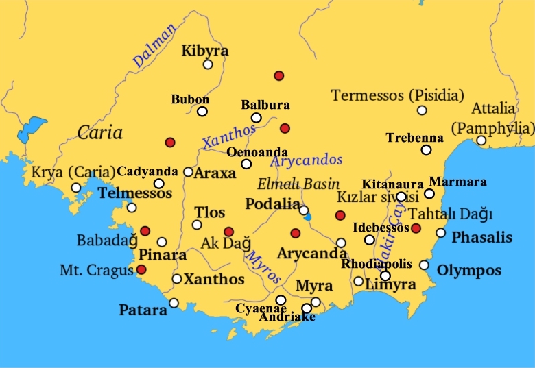
Marmara (Lycia)
36.6558° N, 30.4804° E
About
Marmara, identified as ancient Mnara, was a significant settlement in Lycia, known for its strategic and defensive prowess during Alexander the Great's invasion in 334 BCE. Situated on a sheer and inaccessible rock acropolis, the town of Marmara featured no city walls but was fortified with towers and strongholds. Its cultural and religious significance is underscored by the presence of a temple dedicated to Artemis, as indicated by a house altar uncovered at Rhodiapolis. The site also includes a bouleuterion overlooking the Pamphylian sea, reflecting its civic organization, and a large cistern indicating advanced water management. During the Hellenistic period, Marmara gained independence as a polis, further highlighting its political relevance in the region.
Gallery
Explore photographs of ancient structures, artifacts, and archaeological excavations
Historical Timeline
Journey through time and discover key events in this site's history
Integration with Phaselis
Late 4th century BCE
Skilled defense against Alexander
334 BCE
Hellenistic independence
3rd century BCE
Archaeological Features
Unique architectural and cultural elements found at this historical site
Defensive Structures
Water Management Features
Public and Civic Structures
Religious and Ritual Structures
Domestic and Habitation Structures
Frequently Asked Questions
Plan Your Visit
Tours, travel arrangements, and practical information
More Sites in Turkey
Melanippe (Lycia)
Ancient coastal town on Mount Phoenicus.
Euromus
Ancient Carian city and temple, 6th century BCE
Lysinia
Ancient town in Pisidia, later Pamphylia.
Library of Celsus
Roman library, early 2nd century CE
Blaundus
Hellenistic city ruins in western Anatolia, Turkey
Larissa Phrikonis
Aeolian city ruins in western Turkey